SA Weather Service confirms KZN Midlands hit by Tornado
Videos showing a tornado in the New Hanover and Greytown areas, north of Pietermaritzburg, have surfaced on social media.
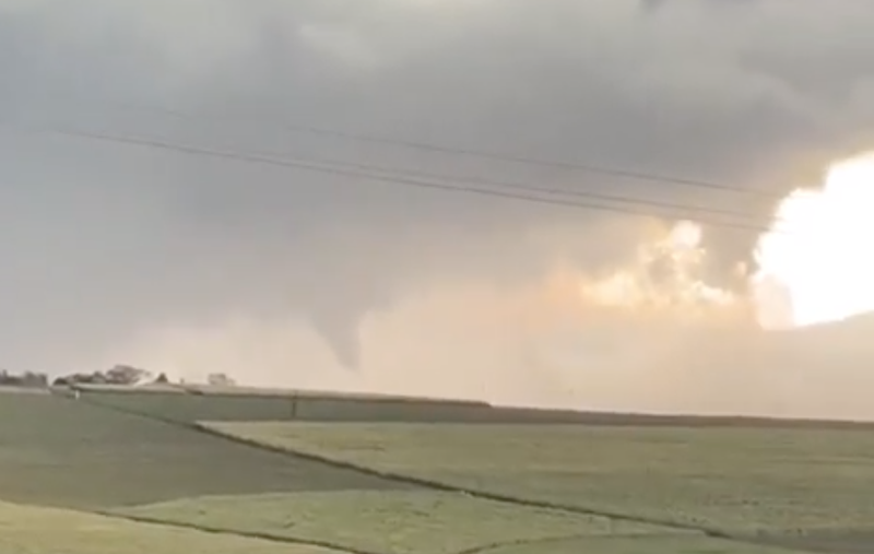
The South African Weather Services has confirmed that the KwaZulu-Natal Midlands was hit by a tornado on Tuesday afternoon.
"At this stage, we can confirm that there was a severe thunderstorm over New Hanover, which developed and formed a tornado. The winds that were driving the storm was quite strong, ranging between 25 and 37 km/h and eventually, a tornado was formed," forecaster, Wiseman Dlamini said.
Watch Weather SA on Twitter said: "Tornadic supercell developed in the Pietermaritzburg area dropping what looks to be a large tornado as well as various reports of severe hail. Instability and wind shear were both supportive of supercells in the area."
Disaster management teams have been activated and dispatched to tornado hit areas.
KZN MEC for Cooperative Governance and Traditional Affairs (Cogta), Sipho Hlomuka says several injuries have been reported.
“Preliminary reports received by the department indicate that a number of people who sustained injuries in the incident are receiving medical attention from surrounding hospitals."
"A number of homes have collapsed, countless trees have been uprooted and the electricity supply in the area has been interrupted. Our teams are working hard to provide support to the affected communities,” he said.
READ: Massive tornado sweeps through KZN Midlands
Several videos have emerged of areas such as New Hanover and Wartburg being battered by the tornado.


I just witnessed a Tornado peoples lost their homes here In Pmb, Empolwen pic.twitter.com/mv8qH04EoS
— LIGHT ROOM PHOTO EDITING SPECIALIST (@faces_li) November 12, 2019
Satellite view of the #Supercell that spurred a #Tornado his afternoon near Wartburg and New Hanover in Kwazulu-Natal#SevereWeather @StormWatchSA @weathertodaysa @ReenvalSA @JoelGuy_ pic.twitter.com/zHeFCKhc4C
— SA Weather🌩️sawx.co.za (@sawx_sa_weather) November 12, 2019
Here is a GFS skew t sounding at 12z south of PMB - where cells developed today. We can see extreme CAPE (>3000j/kg) and some very clear wind shear (becoming directional).
— Weather Whiz kid (@Themeteoguy) November 12, 2019
Img 2 shows cold cloud tops concentrated in the area affected by the tornado ~ Mpolweni. @Albatrossoar pic.twitter.com/GNWNo5nTZn
Tornadic supercell developed in the Pietermaritzburg area dropping what looks to be a large tornado as well as various reports of severe hail. Instability and wind shear were both supportive of supercells in the area. pic.twitter.com/nSdnfZ7jVp
— Weather Watch SA (@storm_sa) November 12, 2019
New Hanover near Pmburg 15mins ago. pic.twitter.com/SadVoKJ65Y
— Paul Kaufmann (@baaspole) November 12, 2019
The SAWS has seen the video of the observed tornado over the KZN Midlands. Numerous severe thunderstorm warnings have been issued for KZN & EC. Any severe thunderstorm has the potential to form a tornado if conditions are conducive. Please see description below. pic.twitter.com/V4UOi67tqo
— SA Weather Service (@SAWeatherServic) November 12, 2019